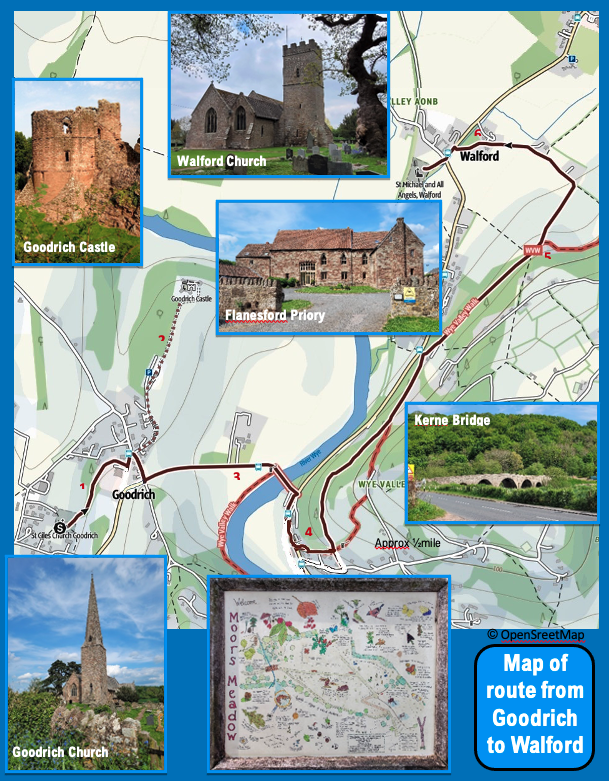
A three mile walk from Goodrich to Walford
- Turn left as you leave St Giles Church and follow the footpath to the bottom lefthand corner of the churchyard. Pass through the gate and follow the footpath along the lower edge of the arable field for a distance of approximately 150 yards. Pass through the gate, over the carved footbridge, and continue to follow the footpath through Moors Meadow along the back of the village school. Pass between the present school building and the old school building (now private houses) to the highway. Turn left and walk a few steps to the bus stop. Cross over the road.
- A worthwhile diversion at this point is to take the lane to Goodrich Castle, (English Heritage, entrance fee) approx 600 yards each way. Goodrich Castle is one of the most complete medieval castles in England. The castle has a café and toilets. A signboard at the entrance to the lane indicates if the castle is open. After a visit retrace your steps.
- Follow the road signposted to Welsh Bicknor, Youth Hostel and Courtfield. After 100 yards the road crosses a road bridge. On your left and to the righthand side of the bridge you will see a footpath leading down some steps. Go down the steps and follow the path at the side of the road (B4229) to Kerne Bridge. As you walk along the road you pass Flanesford Priory (a former Augustinian priory) on your left – a café is open here at weekends in the summer season.
- Cross over Kerne Bridge and turn right on the B4234 (ignore the traffic signpost pointing left for Walford). Take the first track on your left after the ‘Inn on the Wye’ (refreshments available) away from the road. Ignore the first track off to the left. The track becomes a footpath and bears away to your left. It then follows the contour of the hill. The path initially takes you through open countryside but it later becomes wooded.
- After following this footpath for just over a mile, you reach a ruined building. Bear left and continue down the hill and follow the track past Daycroft Farm.
- At the Cider Mill take the footpath on the left which leads to the road. At the road (B4234) cross the road and turn left. You will see the War Memorial in front of you. Walk past it and into the churchyard of St Michael and All Angels, Walford.
A five mile walk from Goodrich to Whitchurch
Distance approximately 5 miles. Distance of alternative route is approximately 3.8 miles.
This walk includes the use of the ferry between Symonds Yat East and
Symonds Yat West. It is advisable in the winter or times of flood t o check that the ferry is operating, by telephoning the Saracens Head Inn on 01600 890435. An alternative route is given in this guide for when the ferry is not operating or you wish to avoid the steep path as you cross Huntsham Hill.
Caution: If you arrive at Symonds Yat East and the ferry is not operating about 4 miles will be added to your walk.
This walk is covered by the Ordnance Survey Explorer Map OL14 – Wye Valley and Forest of Dean.
Thank you for visiting the ancient Church of St Giles Goodrich. We hope you have enjoved your visit. A donation box is located just inside the main door. Your donation will help us maintain the church for future generations to enjoy.
- Turn right as you leave the porch of St Giles Church and then turn immediately right and follow the path to the righthand corner of the churchyard. Pass through the gate and follow the track to the road. Turn left. Cross over the road and follow the path at the side of ‘The Poplars’- one of two new houses. Follow this path as it falls away to join the road just before the ‘Cross Keys Inn’. Turn right down the road. As you approach the ‘Cross Keys Inn’ and opposite ‘Goodrich Manor’ look for a track off to your left between the houses. Follow the track for a short distance until ends and divides into two footpaths. Take the righthand footpath and follow ti for half a mile until it joins the highway. The Cross Keys Inn serves refreshments and food.
- The footpath ends at thebusy B4229 on a fast section of road at a blind bend. Taking great care crossover the road and follow the lane opposite signposted to Symonds Yat East and Yat Rock for about 150 yards until you reach Huntsham Bridge over the River Wye.
Prior to reaching Huntsham Bridge you will see a footpath to the right that runs along the River Wye. This is the start of the alternative route to the Church ofSt Dubricious Whitchurch if the Symonds Yat ferry is not operating. - Cross over Huntsham Bridge. Immediately turn left at the side of the bridge and follow the footpath that runs alongside the river. Keep to the path for about 1.5 miles until it leaves the river to rise steeply.
At about 1mile from Huntsham Bridge an alternative route to Symonds Yat East is available b yfollowing a path to the right – see OS Map OL14. The alternative route still involves crossing over Huntsham Hill. - At the junction with a path descending from the hill turn right and follow the path as it zig zagst o the top of the hill. At the top of the hill continue to follow the path as descends steeply. When you reach the road turn left and follow the track diagonally opposite as it continues its descent into Symonds Yat East.
Symonds Yat East offers a number of tourist facilities. The Saracens Head Inn offers drinks, food and accommodation. There is the Royal Lodge Hotel. Boat trips and canoe hire are available. - The ferry to Symonds Yat West operates from the river landing in front of the Saracens Head Inn. The ferry operator runs to demand. The 2022 fare is €2.
- On leaving the ferry landing turn right. Follow the lane as it runs alongside the River Wye. When the road turns away from the river follow a footpath to the righthand side of the road that continues to run alongside the river for three quarters of a mile. This path enters a wooded area and then crosses the tourist facilities at Symonds Yat West. Continue on theriversidep a t h and the Church of St Dubricious Whitchurch is ahead nestling by the river.
As you walk on the road alongside the river you will pass the Old Ferrie Inn on your right hand side set between the road and the river. The Inn offers refreshment, food and accommodation. Self service tea and coffee and toiletss are available at Whitchurch Church.
ALTERNATIVE ROUTE TO THE CHURCH OF ST DUBRICIOUS WHITCHURCH TO USE WHEN THE SYMONDS YAT FERRY IS NOT OPERATING.
- Follow the directions for the main walk to the Church of St Dubricious Whitchurch as far as Stage
- As you walk along the road towards Huntsham Bridge you will see a footpath to your right. Follow this footpath as it runs alongside the river and crosses the field to end at the road (B4229).
- Take great care as the B4229 is busy and narrow at this point. Turn left and walk along the road for 500 yards past the commercial enterprises. At the junction turn right and cross over the A40by the road bridge. Cross over the roads and take ‘OldRoss Road’ as it runs alongside the A40 to end in Whitchurch village centre.
In Whitchurch you will find a number of facilities including ‘The Crown at Whitchurch’ (refreshments, food and accommodation), ‘Woods of Whitchurch’ (refreshments), the ‘Potting Shed Cafe’ (meals) and the ‘Old Court Hotel’ (refreshments, food and accommodation). - Cross over the A40 by the road bridge and follow the road as it descends from the bridge to sweep round to end at a roundabout. Take the exit from the roundabout that passes in front of the school, Butterfly Zoo and Maze and the Old Court Hotel. Immediately past the Butterfly Zoo the road turns right and on the lefthand side of the road on the bend is the wide main entrance to the tourist facilities at Symonds Yat West. Squeezed between the grounds of the ButterflyZoo and main entrance to the tourist facilities is a signposted track leading to the Church of St Dubricious Whitchurch. Follow this track to the end to reach the church nestling on the bank of the River Wye,
St Giles’ Church, Goodrich
St Giles’ Church is a Grade 2* listed medieval sandstone building in an elevated position in the village and the churchyard contains 27 Grade 2 listed structures. There has been a church in Goodrich since about 1100 but the present building dates from the 1200s. In the course of the English Civil War, it is probable that the Parliamentary army destroyed anything in the church with which they disagreed, including the stained glass windows, a prayer cross and the altar. As with many of our churches, the Victorians carried out extensive alterations to the building in the 1870s.
One of the mysteries of the church are the two carved heads on the east wall to the right of the altar. The style dates them at about 1450 but who or what they represent remains a mystery. There are several items of 17th century furniture, a chest used by Thomas Swift when vicar of Goodrich during the Civil War and the Moffatt chair dating from 1630-40. Thomas Swift’s grandson, Jona-than, author of Gulliver’s Travels, donated the silver chalice used by his grandfather to the church. The poet, William Wordsworth is reputed to have written one of his works whilst pausing in the churchyard on his walking tour of the Wye Valley.
Postcode: HR9 6JA
OS Grid Ref: SO 572 190
Open: until 7 daily
Car Parking: In village
Nearby, within 10 minutes walk:
- The Hostelrie, pub, restaurant (Wednesday to Sunday) and B&B
- The Castle Café, light lunches, afternoon tea (open daily) Goodrich Castle (English Heritage)
